Puerto Blest: Complete Guide 2026
The Blest arm, the Cascada de los Cántaros waterfall and Lake Frías

Last update:
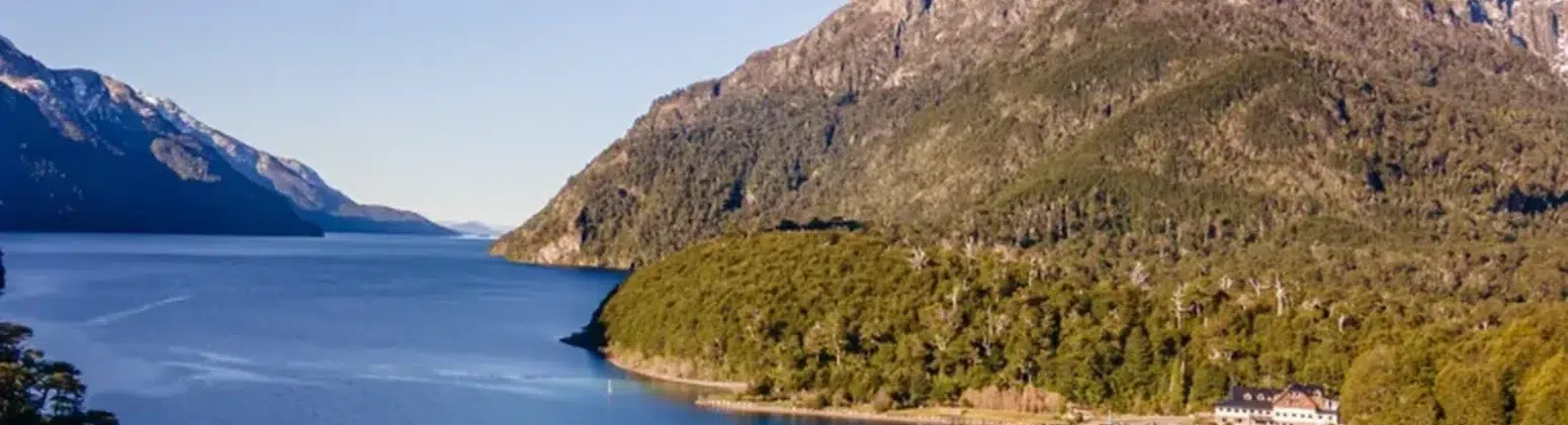
Port Blest It is the wettest and greenest corner of Nahuel Huapi National Park: a small port at the end of the Blest arm of Lake Nahuel Huapi, Surrounded by Valdivian rainforest and with no road leading to it, it can only be accessed by boat. Along the way are the Waterfall of the Jugs, with a larch tree over 1,500 years old next to the path, and on the other side of the port the Lake Frías, of green water due to the sediment that comes down from Mount Tronador.
| Location | Westernmost point of the Blest arm, Lake Nahuel Huapi, Nahuel Huapi National Park, Río Negro |
|---|---|
| Access | Only accessible by boat from Puerto Pañuelo, km 25 of Avenida Bustillo |
| Duration of the excursion | About 8 hours since departure |
| Climate | More than 3 meters of rain per year: it rains at any time of year |
| Waterfall of the Jugs | Approximately 700 wooden steps, optional climb |
| ancient larch | More than 1,500 years old, halfway along the waterfall trail |
| Accommodation | Hotel Puerto Blest, the only one on the arm |
| How to visit it | Navigation Puerto Blest and Cascada de los Cántaros |
Where is Puerto Blest located?
Puerto Blest is at the end of Blest arm, The most enclosed and forested area of Nahuel Huapi, west of Bariloche and near the border with Chile. The mountains plunge steeply into the water, and the Valdivian rainforest reaches the shore. Since there is no road, all boats depart from Puerto Pañuelo, opposite the Llao Llao Hotel, at km 25 of Circuito Chico.
The rainiest corner of the park
The Blest arm of the lake receives over three meters of rain annually. This humidity explains the landscape: coihue trees, larches, colihue cane, ferns, and moss covering every surface. The fog and rain don't spoil the visit; they're part of what people come to see.
What to see in Puerto Blest
Sentinel Island
Shortly after leaving Puerto Pañuelo, the boat passes in front of Isla Centinela, where the remains of Perito Francisco P. Moreno rest, the explorer who donated the lands that gave rise to the country's first national park.
Cascada de los Cántaros and the ancient larch tree
The landing is at the foot of the waterfall trail: about 700 wooden steps that rise alongside the river between successive waterfalls. Halfway up is the larch tree over 1,500 years old which made the place famous. The climb is optional and the steps may be wet.
Puerto Blest and Lake Frías
Crossing the arm of the river leads to the port and its historic early 20th-century hotel. From there, you can access the riverbank. Lake Frías, Its milky green color is a product of glacial sediment from Mount Tronador. Some tours include a boat trip on Lake Frías.
I chose how to get to know Puerto Blest
🇨🇱 Andean Crossing
From Bariloche to Puerto Varas via three lakes, passing through Puerto Blest
Three ways to get to Puerto Blest
They all depart from Puerto Pañuelo, but end up in very different places:
| Option | What is | Ideal for |
|---|---|---|
| Puerto Blest and Cascada de los Cántaros | Approximately 8-hour boat trip including the waterfall, the larch tree, and the port. Return to Bariloche the same day. | For those who have a day and want classic sailing |
| Hotel Puerto Blest | Accommodation in the only hotel on the arm, with trails to the waterfall, the Peninsula and the Frias River. | See the place without people, at sunset and sunrise |
| Andean Crossing | International transfer with three voyages ending in Puerto Varas, Chile. It does not return to Bariloche. | Continue your journey to Chile |
| Cloud Passage | Two-day trekking journey from Pampa Linda that ends by sailing on Lake Frías and the Blest arm. | Trekkers with mountain experience |
Best time to visit Puerto Blest
The boat trip operates year-round and departs rain or shine. Strong winds on the lake are the only factors that may cause it to be rescheduled.
| Season | Months | What to expect |
|---|---|---|
| Summer | Dec-Feb | Longer days and more chances of sunshine. High season: book in advance. |
| Autumn | Mar-May | Forest with colors and fewer people on the trails. |
| Winter | June-August | Lots of rain and cold, waterfalls with more flow. |
| Spring | Sep-Nov | Meltdown, full waterfalls and more wind over the lake. |
Tips for Puerto Blest
- Waterproof jacket is a must: It is one of the rainiest places in the country, at any time of year.
- Shoes with good soles: The 700 steps of the waterfall are usually wet.
- Cash: The boarding fee and the entrance fee to the National Park are paid at the port.
- Transfer: The pick-up to Puerto Pañuelo is optional and must be arranged separately.
- If you are interested in the Tronador: It's not always visible from Puerto Blest. To see it head-on, the option is... excursion to Cerro Tronador.
Frequently Asked Questions about Puerto Blest
How do you get to Puerto Blest from Bariloche?
Only by boat. Boats depart from Puerto Pañuelo, 25 km from downtown Bariloche via Avenida Bustillo, and cross Lake Nahuel Huapi to the Blest arm. There is no road to Puerto Blest.
How long does the excursion to Puerto Blest last?
The Navigation to Puerto Blest and Cascada de los Cántaros It lasts about 8 hours from departure in Puerto Pañuelo, with return to Bariloche on the same day.
Is it difficult to climb to the Cascada de los Cántaros?
There are about 700 wooden steps that can be wet and slippery. Climbing them is optional and won't affect the rest of your day.
What is the difference between Puerto Blest and the Andean Crossing?
They share the first leg through the Blest arm, but the excursion to Puerto Blest returns to Bariloche the same day. The Andean Crossing is an international transfer that ends in Puerto Varas, Chile.
Is it possible to sleep in Puerto Blest?
Yes, in the Hotel Puerto Blest, The only accommodation on the arm of the river. It is reached by the same boat and allows you to explore the trails without crowds.
Does the tour go on if it rains?
Yes. Rain is common in the Blest arm, and the misty forest is part of the landscape. It's only rescheduled due to strong winds over the lake.